Section 18 report: Flood and Coastal Erosion Risk Management in Wales 2023 – 2025
Executive summary
This report on Flood and Coastal Erosion Risk Management (FCERM) in Wales is produced as a requirement under section 18 of the Flood and Water Management Act 2010. It provides an update to Welsh Ministers on progress made in implementing the Welsh Government’s National Strategy for Flood and Coastal Erosion Risk Management published in October 2020.
The National Strategy for Flood and Coastal Erosion Risk Management in Wales (2020) sets Welsh Government’s aims and objectives for managing flooding, as well as the measures to be taken over the next decade by Risk Management Authorities (RMAs) and others to improve how we plan and prepare for, respond and adapt to, the risks from flooding.
This ‘Section 18 report’ (as it is commonly termed) details progress made against the Strategy and measures and the objectives over the period April 2023 to March 2025. It also includes other information that Welsh Government has requested be reported (as detailed in Para 335 of the National Strategy). It is a factual report and compiled from information provided by the RMAs operating in Wales, and we gratefully acknowledge the assistance of partner organisations in producing this update.
There are 24 measures in the National Strategy and this report shows that:
- 17 measures are already complete, although 10 of those require related ongoing activities to continue and 4 require the consideration of next steps,
- 6 are underway, and
- 1 is on hold.
For comparison purposes, in the last Section 18 report produced in 2023, 13 measures were complete, 9 underway and 2 yet to start or on hold. This shows that good progress has been made throughout the reporting period on delivering the measures and consequently the objectives within the Strategy. However, there are several areas of work that remain underway or not yet started and there is clearly key further work to be completed.
This Section 18 report includes information on flood events during the period and major schemes completed including alleviation works at Stephenson Street, Newport; Ammanford, Carmarthen; Kinmel Bay and Llandudno, Conwy.
This report contains examples of good FCERM practice in the sector, including:
- Innovative projects from Wales Coastal Monitoring Centre and Natural Resources Wales.
- Natural Flood Management schemes in Monmouthshire, Conwy and Caerphilly.
- Partnership working on projects in Pembrokeshire and Caerphilly.
- Information provision by Natural Resources Wales through the launch of the new Flood Warning Information Services for Wales (FWISfW), the telemetry replacement project and the publication of the Long Term Investment Requirements.
- Community participation events held by RMAs including Pembrokeshire, Caerphilly and Natural Resources Wales.
Introduction
Natural Resources Wales (NRW) has a statutory duty under section 18 of the Flood and Water Management Act 2010 to produce a report for the Welsh Ministers about the application of the Welsh Government National Flood and Coastal Erosion Risk Management (FCERM) Strategy (the ‘National Strategy’ or ‘strategy’). This duty is delivered through the production of this report, commonly known as the ‘Section 18 report’. This is a factual report and draws on information supplied by the Risk Management Authorities (RMAs) in Wales, and relevant others. It covers the period from April 2023 to March 2025.
Welsh Government has specified the content requirements of the Section 18 report in its National Strategy, paragraph 335.
Figure 1: Extract from the Welsh Government National Flood and Coastal Erosion Risk Management Strategy detailing how the strategy should be monitored.
This Section 18 report is split into three parts to best capture the monitoring and reporting requirements of the National Strategy. Part one provides an update against the National Strategy measures and objectives including an update against each measure. Part two provides an update against the remaining elements of paragraph 335 and includes case studies examples that have been provided by Risk Management Authorities. Part three presents the annual reporting that Natural Resources Wales carries out which further demonstrates and provides examples of the delivery of the Strategy’s objectives.
Previous Section 18 reports have been produced tracking progress against the National Strategy between 2011 to 2023. These are available through the NRW website.
An update on the National Flood and Coastal Erosion Risk Management (FCERM) Strategy measures and objectives
Introduction
The National FCERM Strategy has an overarching aim and five objectives, with a stated intention in the Strategy that they collectively reduce the risk to life.
Aim: Reduce the risk to people and communities from flooding and coastal erosion
Objectives:
A. Improving our understanding and communication of risk
B. Preparedness and building resilience
C. Prioritising investment to the most at risk communities
D. Preventing more people becoming exposed to risk
E. Providing an effective and sustained response to events
Delivery of objectives
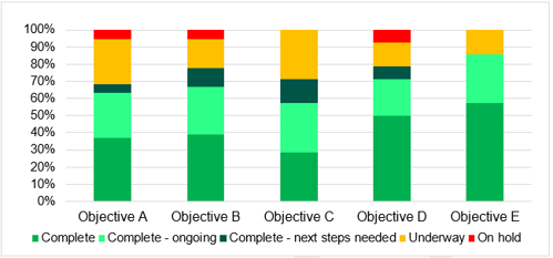
The National Flood and Coastal Erosion Risk Management Strategy has 24 measures that delivery against the five objectives. Each measure is assigned to the delivery of at least one objective – so there is not a direct one to one relationship between the objectives and the measures. The chart below provides a visual representation of progress against each of the objectives by showing the status of the measures that are aligned (by Welsh Government, in the Strategy) to each objective. By this analysis, only one measure is on hold (which contributes to three objectives), which means that now all objectives are at least 93% complete or underway compared to 85% to 100% in the last report. Of the five objectives, Objective E is the most advanced, while Objective C is the least advanced. The coming years will see the remaining measures expected to be taken forward into delivery.
Figure 2: Chart showing delivery progress of each National FCERM Strategy objective
Whilst the measures in the Strategy are expressly linked to the objectives, there are of course other activities outside of the measures that deliver against the objectives. For example, the Natural Resources Wales Annual Reports describe the range of activities undertaken by NRW, all of which deliver across a range of the objectives in the National Strategy. These are included within Part three of this report.
Summary of progress of the Measures
The National FCERM Strategy contains 24 measures that will help deliver the aim and the objectives. The following table provides a summary of progress against each measure. Further dialogue as to how each measure is progressing is included in the section following the table.
Each measure has been assigned one of the following states
- Complete – the measure has been delivered in line with the National Strategy.
- Complete – next steps needed – the measure has been delivered, however further work is required to take account of recommendations or to deliver additional outcomes.
- Complete – ongoing – the measure has been delivered, however it relates to activities that need to continue on an ongoing basis
- Underway – work to deliver the required action has commenced
- On hold – work to deliver the required action has been halted for given reasons
Table 1: Summary progress against the National Flood and Coastal Erosion Risk Management strategy measures (previous update status is included in italics)
|
No. |
Measure |
Lead |
Objective |
Summary update |
|---|---|---|---|---|
|
1 |
Flood and Coastal Erosion Committee to establish the scope and consider the need for changes to legislation to clarify and support the delivery of FCERM in Wales by 2022 |
FCEC |
A - E |
Complete – next steps needed The final report was approved by the Flood and Coastal Erosion Committee (FCEC) in September 2022 and submitted to the Minister. The Minister has responded and the Committee now have a shortlist of legal change work. |
|
2 |
Delivery of annual topographic surveys by Wales Coastal Monitoring Centre on behalf of Coastal Groups to measure change in the most at risk coastal areas in Wales |
Coastal Groups and WCMC |
A & C |
Underway 64% of the planned 10 year survey programme has been undertaken so far.
|
|
3 |
NRW to publish new Flood Risk Assessment Wales (FRAW) maps in 2020 alongside the Strategy and update every 6 months to reflect changes in National Asset Dataset |
NRW |
A - E |
Complete – ongoing NRW published the new FRAW maps in October 2020 on the NRW website and through DataMapWales. NRW have produced FRAW updates every 6 months in May and November. |
|
4 |
NRW to provide data on the number of homes and businesses at high, medium and low risk of flooding from all sources on an annual basis based on FRAW updates |
NRW |
A & C |
Complete – ongoing In 2024, NRW provided a National update to the number of residential and non-residential properties at high, medium and low risk of flooding. This will be updated in summer 2025. |
|
5 |
Risk Management Authorities to update maps, plans and data in line with the schedule set out in Figure 12 of the National Strategy |
NRW, Local Authorities |
A - E |
Complete – ongoing NRW maintain a number of flood and coastal erosion risk maps which are updated in line with the National Strategy. NRW and Lead Local Flood Authorities (LLFAs) also produce plans in line with Figure 12 of the National Strategy. |
|
6 |
NRW and Local Authorities will work together to ensure that by end of 2021 the National Asset Database will contain data on all FCERM assets owned or designated by Risk Management Authorities |
NRW, Local Authorities |
A - D |
Complete NRW published an interactive map "Find flood defence structures near you (The National Flood Asset Database)" in December 2021. The map now contains data from all Welsh LLFAs (as well as NRW data). |
|
7 |
NRW will work with Local Authorities to develop a process to ensure all updates are incorporated in the National Asset Database within 6 months of any completed works or changes otherwise required, by the end of 2021. |
NRW, Local Authorities |
A - D |
Complete During development of the National Flood Asset Database, NRW developed a process and webpage that is to be used by LLFAs to submit any changes. |
|
8 |
NRW to utilise the National Asset Database to ensure Wales Flood Map reflects the reduced risk from all flood alleviation schemes by 2022 |
NRW |
A - D |
Complete The Wales Flood Map is updated every 6 months using the most up to date information from NRW’s mapping and modelling programme and asset data (from the process in measure 7). |
|
9 |
NRW to ensure the National Coastal Erosion Risk Map (NCERM) matches Shoreline Management Plan (SMP) policies by 2021 and shows erosion rates as bands in the Wales Flood Map products by end of 2022 |
NRW |
A - E |
Complete NRW published NCERM maps on the website which shows coastal erosion and SMP information in map format. |
|
10 |
Coastal Groups to report annual progress on SMP Action Plans to the Welsh Government through the Wales Coastal Group Forum |
Coastal Groups |
A - D |
Complete – ongoing The Wales Coastal Group Forum produces an annual progress report for Welsh Government. As of October 2024, there are 253 actions remaining. |
|
11 |
Coastal Groups to report on the implementation of SMP2 epoch 1 policies, through Wales Coastal Group Forum to the Welsh Government, by 2025 |
Coastal Groups |
A - D |
Underway Work has begun through the Wales Coastal Group Forum to report on the implementation of SMP2 epoch 1 policies. Dedicated leads have been nominated within each Coastal Group and a reporting proforma has been developed. |
|
12 |
NRW to complete their online flood information improvements, working with Welsh Local Government Association (WLGA) and Local Authorities, by 2021. This will include publication of the Wales Flood Map products, understanding flood warnings and advice on building resilience and responding to flooding |
NRW |
A, B, D & E |
Complete NRW have published a number of improvements to online information including improvements to the flood risk map and flood related information.
|
|
13 |
The Welsh Government will fully fund Natural Flood Management (NFM) schemes for a trial period, commencing 2020/21, and publish new guidance to further encourage take-up and the sharing of lessons on its practical delivery |
Welsh Government |
A, B & C |
Complete – ongoing After the success of the Welsh Government NFM pilot programme a subsequent Accelerator programme was established which has made £4.5m available to continue take-up of NFM in Wales. |
|
14 |
The Welsh Government will work cross policy to ensure NFM is considered in wider land and water management, including agriculture and in NRW Area Statements |
Welsh Government |
A, B & C |
Underway Welsh Government and NRW are working to make sure there are good cross policy links between flooding and agriculture, especially by integrated NFM into the Sustainable Farming Scheme. |
|
15 |
The number of NFM and hybrid schemes undertaken will be reported to the Welsh Government annually through grant reporting, and reported to Welsh Ministers by NRW in the Section 18 report |
All RMAs |
A, B & C |
Complete – ongoing Welsh Government have made improvements to their programme management system and forms which facilitates better information gathering and monitoring of NFM schemes. |
|
16 |
The Welsh Government to commence a review of the effectiveness of Sustainable Drainage Systems (SuDS) legislation in 2021 |
Welsh Government |
B & C |
Complete – next steps needed Welsh Government have completed a review into the effectiveness of SUDs. |
|
17 |
The Welsh Government to update TAN15 by 2021 recognising the flood risk information now available to Local Planning Authorities |
Welsh Government |
B & D |
Complete The updated planning advice on flooding through a new Technical Advice Note 15 (TAN) was published on 31st March 2025. |
|
18 |
The Welsh Government to work with the Coastal Groups and NRW to develop further guidance on coastal adaptation by 2022 |
Welsh Government and Coastal Groups |
A, B & D |
On hold Welsh Government published the Climate Adaptation Strategy for Wales in October 2024 which outlines the significant commitment to responding to the changing climate. |
|
19 |
NRW to develop and establish an appropriate monitoring programme to support and inform the National Habitat Creation Programme by 2022 |
NRW |
C |
Underway Monitoring of predicted losses continues to be taken through Coastal Squeeze Assessments at a project level. Monitoring and routine survey work is underway at compensatory sites. |
|
20 |
The Welsh Government, WLGA, NRW and Local Resilience For a (LRFs) to standardise immediate reporting of flooding to properties and erosion events by end of 2021, in line with the Wales Flood Response Framework |
Welsh Government/ Wales Flood Group |
A, C & E |
Complete Following review with RMAs and wider resilience providers, there will be no changes. |
|
21 |
Flood and Coastal Erosion Committee, WLGA and Local Authorities to collaborate and establish high-level requirements and supporting guidance for Section 19 flood investigation reports by 2023 |
FCEC / WLGA and Local Authorities |
A, C & E |
Underway Professor Elwen Evans completed work to review Section 19 reporting in Wales in summer 2023. The FCEC has established a Sub-Committee to review the report. |
|
22 |
The Welsh Government will work with Risk Management Authorities to develop a 5 to 10 year investment programme pipeline |
Welsh Government and all RMAs |
A - D |
Underway Welsh Government will work collaboratively with all RMAs to consider future investment needs by using prioritisation options from Local Authority strategies and NRW’s Flood Risk Management Plan. |
|
23 |
NRW will work with Local Authorities and the Welsh Government to publish long-term investment requirements for FCERM, complementing FRAW, by end of 2021 |
NRW |
A - D |
Complete – next steps needed NRW published its Long-Term Investment Requirements (LTIR) for managing the flood defence asset base in Wales in 2023. We are currently considering potential further work to strengthen the LTIR evidence and develop a strong investment case around all aspects of Flood Risk Management. |
|
24 |
The Flood and Coastal Erosion Committee will explore opportunities to maximise partner contributions and investment in FCERM by 2022 |
FCEC |
C |
Complete – next steps needed Progress has been made against this measure through undertaking a number of projects including undertaking an environmental sustainability skill and capacity review and holding a workshop with the Deputy First Minister to highlight the issues facing the sector. |
Further information on progress of the Measures
Measure 1
Flood and Coastal Erosion Committee to establish the scope and consider the need for changes to legislation to clarify and support the delivery of FCERM in Wales by 2022.
Lead: FCEC
Status: Complete – next steps needed
Update: The Final Report “The Case for Change in Legislation and Associated Policy on FCERM in Wales” was approved by the Committee in September 2022 and submitted to the Minister. The Minister responding in November 2023, and as a result, the Committee has decided to focus further legal change work on the following:
- The control of FCERM assets, including the designation of features under Schedule 1 of the Flood & Water Management Act 2010;
- Roles and responsibilities;
- Flood risk adaptation, both on the coast and inland, and flood resilience.
- Review of the Elwen Evans Report into Local Government Section 19 reports;
- Review of mechanisms for securing investment in assets not in RMA ownership;
- Review of legislative constraints on water companies, in particular in reducing discharges from combined sewers
Measure 2
Delivery of annual topographic surveys by Wales Coastal Monitoring Centre (WCMC) on behalf of Coastal Groups to measure change in the most at risk coastal areas in Wales.
Lead: Coastal Groups and WCMC
Status: Underway
Update: In 2019 a strategic survey programme was implemented to focus annual topographic surveys on the most at risk coastal locations in Wales. This is a 10 year adapting programme that is dependant upon funding.
As of March 2025, the WCMC have completed around 64% of the planned survey programme. This equates to 949 out of 1492 planned surveys.
Annual Reports published by the WCMC provide further insight into their work and the progress of the survey programme.
Measure 3
NRW to publish new FRAW maps in 2020 alongside the Strategy and update every 6 months to reflect changes in National Asset Dataset.
Lead: NRW
Status: Complete - ongoing
Update: We have continued to produce bi-annual updates to the Flood Risk Assessment Wales (FRAW) map every May and November, to include any new or improved flood risk information for Rivers and the Sea. This information is based on more detailed, ‘local’ flood studies and ensures the map contains the best information available to NRW.
Where we are provided with information, we show the benefit (e.g. the reduction in risk) from new flood defences and, using information from the National Asset Dataset, identify the location of raised flood defences in the FRAW map.
We have also made improvements to the online viewer used to display the Flood Risk Assessment Wales Map (FRAW) to improve accessibility, provide an enhanced user experience, and to meet Welsh language requirements.
Measure 4
NRW to provide data on the number of homes and businesses at high, medium and low risk of flooding from all sources on an annual basis based on FRAW updates.
Lead: NRW
Status: Complete - ongoing
Update: In 2024 we provided a national update to the number of residential and non-residential properties at high, medium and low risk of flooding. This information was published in NRW’s Flood risk management annual report 2023 to 2024, is displayed on the Stats Wales website (flooding) and shared directly with Lead Local Flood Authorities. This data has been updated on an annual basis since.
Measure 5
Risk Management Authorities to update maps, plans and data in line with the schedule set out in Figure 12 of the National Strategy.
Lead: NRW, Local Authorities
Status: Complete - ongoing
Update: NRW maintain a number of flood and coastal erosion risk maps, products and plans. The frequency of update is detailed in the table below alongside updates on the latest with each of these tasks, as well as some tasks delivered by other Risk Management Authorities. The majority are effectively complete but require ongoing work or updates, the development of Local Flood Risk Management Strategies remain ongoing and are expected to complete in 2025/26.
Table 2: Table showing the digital products that Risk Management Authorities maintain and their frequency of update
|
Map/data/plan |
Frequency of update |
Additional information |
|---|---|---|
|
Wales Flood map |
Every 6 months |
The Wales Flood Map (which includes the FRAW map and the Flood Map for Planning) has been updated every 6 months, in May and November each year, to include any new, or updated flood risk information that becomes available to NRW. At the same time, we have made improvements to the online viewer used to display the Wales Flood map to improve accessibility, provide an enhanced user experience and to meet Welsh language requirements. The work has also ensured that the FRAW map and the Flood Map for Planning have the same ‘look and feel’ providing a consistent and joined-up experience for users navigating between maps. |
|
FRAW map |
Every 6 months |
We have continued to provide local updates to the FRAW map every 6 months, in May and November, with any new or updated flood risk information for Rivers and the Sea. Discussions have taken place with LLFAs and the WG about requirements for updating the surface water and small watercourses component of the FRAW map which is updated less frequently due to the absence of any new or improved local model information. At the same time we have also made improvements to our Check your flood risk by postcode service. This service provides users with an alternative means of obtaining their flood risk information (that is not map based). |
|
Flood Map for Planning |
Every 6 months |
The Flood Map for Planning officially replaced the Development Advice Map in March 2025 following the launch of Welsh Government’s updated TAN15. We have continued to provide local updates to the Flood Map for Planning every 6 months, in May and November, with any new or updated flood risk information. |
|
NCERM map |
Ad hoc as required |
The first edition NCERM map was published in December 2022. |
|
Communities at Risk Register (CARR) |
Annually |
An ‘interim’ update to the Communities at Risk Register (CaRR 2024) was released in January 2025. The purpose of this release was to obtain feedback from Users on potential changes to risk rankings prior to a full release in Summer 2025. At the same time, work has been undertaken to improve accessibility to the CaRR through an improved ‘data pack’ to LLFA’s (helping them to better understand the data and methodology used to produce the CaRR) and improved information, including a link to a new online Viewer of community polygons and rank, created on NRW’s website (Natural Resources Wales / How we plan and prioritise our flood risk management work). |
|
National asset database |
Every 6 months |
Updated following voluntary LLFA submissions on an annual basis. |
|
Shoreline Management Plans (SMPs) |
As new data available |
Phase 2 of a SMP refresh started in 2023/24 (including improvements to SMP content on our coastal risk maps in December 2023) and should conclude by end of 2025/26. Further information can be found about the refresh project on the Shoreline Management Plan page. |
|
Preliminary Flood Risk Assessment |
Every 6 years |
Preliminary Flood Risk Assessments were produced covering the Dee, the Severn and the Western Wales River Basin Districts for all sources of flood risk in 2018. The Flood Risk Regulations were revoked in December 2023 so there will be no further updates. |
|
Flood Risk Management Plans |
Every 6 years |
NRW’s Flood Risk Management Plan has been updated and published in November 2023. The Flood Risk Regulations were revoked in December 2023. We are undertaking work to consider the future of strategic flood plans in Wales. |
|
Local Flood Risk Management Strategy |
Within 2 years of National Strategy |
Local Authorities are updating their Local Flood Risk Management Strategies and expected to be complete during 2025/26. |
Measure 6
NRW and Local Authorities will work together to ensure that by end of 2021 the National Asset Database will contain data on all FCERM assets owned or designated by Risk Management Authorities.
Lead: NRW, Local Authorities
Status: Complete
Update: NRW published an interactive "Find flood defence structures near you (The National Flood Asset Database)" map in December 2021 with asset data from NRW and 16 Lead Local Flood Authorities (LLFAs). We have now had agreement from all 22 LLFAs to share their key flood asset data.
Submissions have moved from an annual autumn collection to voluntary LLFA updates, when data is of a sufficient quality and standard for LLFAs to share. This approach has been agreed with Welsh Government officials.
Bringing this information together will ensure that Welsh Government investment in improved flood defences is reflected in both our flood risk and economic modelling, improving decision making and making our flood risk models more accurate.
Measure 7
NRW will work with Local Authorities to develop a process to ensure all updates are incorporated in the National Asset Database within 6 months of any completed works or changes otherwise required, by the end of 2021.
Lead: NRW, Local Authorities
Status: Complete
Update: As part of the delivery of measure 6, a process and webpage was developed for updates to the National Asset Database and this information was provided to Local Authorities. The process encourages early conversations with NRW teams during Local Authority scheme development to ensure compatibility of information with the database. This may involve a "Flood Map Challenge" process, as well as submission of good quality asset information. Depending on the size and complexity of a project a flood map challenge may take up to 6 months before being accepted. To date, NRW has received a limited number of submission from LLFAs during this reporting period.
Measure 8
NRW to utilise the National Asset Database to ensure Wales Flood Map reflects the reduced risk from all flood alleviation schemes by 2022.
Lead: NRW
Status: Complete
Update: The Wales Flood Map continues to be updated on a 6 monthly cycle with up to date risk data from NRW’s mapping and modelling programme and any successful challenges submitted from LLFAs or developers.
This incorporates NRW’s flood schemes, or risk and asset data from Local Authorities submitted and accepted by NRW as part of measure 7.
Measure 9
NRW to ensure the National Coastal Erosion Risk Map (NCERM) matches SMP policies by 2021 and shows erosion rates as bands in the Wales Flood Map products by end of 2022.
Lead: NRW
Status: Complete
Update: NRW completed work to improve the visualisation of coastal erosion data in map products by publishing the ‘Coastal risk' map online. The map shows NCERM data as spatial bands which give a projection of anticipated erosion over the short, medium and long term scenarios with a percentage confidence range. This will enable homeowners and partners to understand the level of risk to the coast from coastal erosion.
The maps also contain the latest update of the Shoreline Management Plan data (yellow line) and the tidal flood risk maps from FRAW mapping (green zones). The SMP data allows users to quickly understand policy unit extents and their management policies, with further information available when you click on the line.
Measure 10
Coastal Groups to report annual progress on SMP Action Plans to the Welsh Government through the Wales Coastal Group Forum.
Lead: Coastal Groups
Status: Complete - ongoing
Update: Since the last Section 18 report was produced, Coastal Groups are now using the SMP Refresh Action Plan template through the SMP Refresh process. As part of the transition to the new process, Coastal Groups undertook a further action plan rationalisation exercise to sense check and streamline SMP Action Plans to make them more accurate, actionable and realistic. This reduced the number of active SMP actions from 631 in 2022 to 253 in 2024. This review of SMP Action Plans should allow Coastal Groups to prioritise shorter term actions, informed by their tailored Health Check Reports produced in 2020/2021.
As of October 2024, of the remaining 253 actions, 29% are progressing, 5% are planned and programmed, 41% are on hold due to a mixture of resource, funding and delivery constraints, 24% are not yet started and 1.6% are unknown.
Measure 11
Coastal Groups to report on the implementation of SMP2 epoch 1 policies, through Wales Coastal Group Forum to the Welsh Government, by 2025.
Lead: Coastal Groups
Status: Underway
Update: Work has begun through the Wales Coastal Group Forum to report on the implementation of SMP2 epoch 1 policies. Dedicated leads have been nominated within each Coastal Group and a reporting proforma has been developed to ensure a consistent approach.
At the time of writing this section 18 update, leads have met numerous times and are making progress. They plan to meet again to discuss provisional results alongside Forum members, specifically Welsh Government and NRW, to help form the base of the report on the implementation of SMP2 epoch 1 policies for Welsh Government.
Measure 12
NRW to complete their online flood information improvements, working with WLGA and Local Authorities, by 2021. This will include publication of the Wales Flood Map products, understanding flood warnings and advice on building resilience and responding to flooding.
Lead: NRW
Status: Complete
Update: NRW have made significant improvements to online flood products in recent years. These include:
- The publication of new digital services including River Levels, Rainfall and Sea Data, Flood Warnings and Alerts and Five Day Flood Risk for Wales. These new digital products provide a better customer journey, more data (rainfall and sea level data), clearer information/advice, much greater service resilience at time of peak demand and compliance with accessibility standards.
- Improvements to the NRW website to make advice and information more easily accessible with improved signposting to organisations that can help with housing, mental health advice, traffic information, evacuation procedures, energy supplies and funding.
- The development of a ‘Check your Flood Risk’ app which gives customers an easier experience when creating a flood risk report for the area around their property and enables a text report output rather than map if required.
- Improvements made to the NRW website to make key flooding information more readily available to the public before, during and after a flood incident including a webpage detailing the responsibility for different types of watercourses.
- Development of a new suite of flood social media assets for use in communicating flood risk and practical actions to the public before, during and after flooding.
- Creation of a ‘report a flood incident’ online form for easy access flood reporting.
- Improvements to NRW’s online flood mapping service through the publication of the Flood Risk Assessment Wales map, the Flood map for Planning and National Coastal Erosion Risk Management map.
Measure 13
The Welsh Government will fully fund NFM schemes for a trial period, commencing 2020/21, and publish new guidance to further encourage take-up and the sharing of lessons on its practical delivery.
Lead: Welsh Government
Status: Complete - ongoing
Update: Following the success of the NFM Pilot Programme which ran from May 2020 to March 2023, a subsequent Accelerator programme was established which made £4.5m available to continue take-up of NFM in Wales. A further £2m has been made available from 2025/26 to further support NFM in Wales.
The Welsh Government has recently published a suite of opportunity mapping and case study reviews which were completed under the NFM pilot programme. The purpose of this review was to establish how NFM is being delivered, how further work could be prioritised and potential delivery routes including working cross policy.
Measure 14
The Welsh Government will work cross policy to ensure NFM is considered in wider land and water management, including agriculture and in NRW Area Statements.
Lead: Welsh Government
Status: Underway
Update: Welsh Government and NRW are working to make sure there are good cross policy links between flooding and agriculture. This is particularly important for Natural Flood Management which by its nature requires close collaboration to develop and deliver schemes which provide a large range of benefits. We are currently working to integrate Natural Flood Management into the development of the future optional and collaborative layers of the Sustainable Farming Scheme (SFS). When live, this scheme has the potential to help enable and incentivise landowners to utilise nature-based solutions to provide a range of benefits including, flood risk management, water quality and biodiversity. The latest information on the SFS can be found here: Sustainable Farming Scheme | Sub-topic | GOV.WALES.
Measure 15
The number of NFM and hybrid schemes undertaken will be reported to the Welsh Government annually through grant reporting, and reported to Welsh Ministers by NRW in the Section 18 report.
Lead: All RMAs
Status: Complete - ongoing
Update: Welsh Government FCERM Business Case Guidance requires all Risk Management Authorities applying for funding through Welsh Government to consider natural flood management at the short list stage. As a result of this and other works on NFM we are starting to see NFM form a more integral role in the work we deliver.
Welsh Government have made changes to their programme management system and application forms which will help monitoring projects in the programme with NFM elements.
Welsh Government have provided funding to help support NFM based projects through two separate programmes since 2023, the NFM accelerator covering 2023 to 2025 and the NFM fund covering 2025/26. Information on these programmes is provided in the tables below. Please note, some schemes are included in both tables.
Table 3: Natural Flood Management Programme 2023 to 2025
|
Risk Management Authority |
Scheme name |
No. of properties benefitting |
Cost applied for (£k) |
|---|---|---|---|
|
Caerphilly |
Rhymney War Memorial Park |
21 |
270 |
|
Caerphilly |
Parc Cwm Darren |
1 |
39 |
|
Caerphilly |
NFM in schools |
8 |
300 |
|
Caerphilly |
Nant Hafod Tudor |
1 |
40 |
|
Conwy |
Catchment based leaky woody structures |
18 |
70 |
|
Conwy |
Llansannan NFM interventions |
34 |
125 |
|
Conwy |
Capel Curig Leat |
150 |
80 |
|
Conwy |
Y Foel - Landscape enhancement |
150 |
170 |
|
Cyngor Gwynedd |
Bontnewydd |
42 |
271 |
|
Cyngor Gwynedd |
Mynydd Llandegai |
32 |
179 |
|
Denbighshire |
Llanfair DC NFM scheme |
3 |
456 |
|
Denbighshire |
Glanllyn Farm Wigfair NFM scheme |
8 |
299 |
|
Denbighshire |
Gwyddelwern |
17 |
299 |
|
Denbighshire |
Nantglyn |
38 |
219 |
|
Denbighshire |
Pwllglass |
4 |
298 |
|
Monmouthshire |
Kingswood, lower gockett farm and dingestow |
35 |
70 |
|
Neath Port Talbot |
Llantwit and Gnoll NFM schemes |
417 |
118 |
|
NRW |
Dinas Powys scheme |
44 |
360 |
|
NRW |
Dwyran |
16 |
230 |
|
Powys |
Catchment scale leaky woody debris scheme |
1028 |
85 |
|
Powys |
Nant Abel and Afon Cain |
158 |
200 |
|
Powys |
SoIL (solving intractable land-use issues) |
299 |
264 |
|
Powys |
Upper Teme Knighton NFM 2 |
50 |
200 |
Table 4: Natural Flood Management Fund 2025/26
|
Delivery authority |
Project name |
No. of properties benefitting |
Cost applied for (£k) |
|---|---|---|---|
|
Caerphilly |
Rhymney War Memorial (NFM), Rhymney |
21 |
290 |
|
Caerphilly |
Nant Hafod Tudor (NFM), Wattsville |
1 |
45 |
|
Carmarthenshire |
Nant Jac Catchment NFM |
79 |
300 |
|
Conwy |
Llanfair Talhaiarn |
38 |
24 |
|
Conwy |
Ysbyty Ifan |
75 |
11 |
|
Conwy |
Gwen Gof Isaf and others |
75 |
50 |
|
Conwy |
Pwllycrochan Woods NFM |
21 |
27 |
|
Gwynedd |
Criccieth NFM |
27 |
210 |
|
Gwynedd |
Waunfawr NFM |
46 |
180 |
|
Denbighshire |
Llanfair DC Natural Flood Management Schem |
3 |
230 |
|
Denbighshire |
Pwllglas NFM Scheme |
4 |
200 |
|
Flintshire |
Swinchiard Brook NFM |
27 |
270 |
|
Flintshire |
Dyserth catchment NFM |
55 |
25 |
|
Flintshire |
Maes Garmon NFM |
11 |
60 |
|
Flintshire |
Pullford Catchment NFM |
78 |
295 |
|
Flintshire |
Hawarden NFM |
21 |
50 |
|
Flintshire |
Greenfield Valley NFM |
35 |
200 |
|
Flintshire |
Fullbrook Greenfield NFM |
21 |
50 |
|
NPT |
Brynau Wetlands NFM Scheme |
417 |
85 |
|
NPT |
Tonmawr NFM |
0 |
55 |
|
NRW |
Integrated Cadoxton Catchment Approach |
44 |
300 |
|
NRW |
Ely Catchment NFM |
2 |
83 |
|
Powys |
Wye SOIL |
151 |
296 |
|
Powys |
Knighton to Newtown NFM |
169 |
128 |
Measure 16
The Welsh Government to commence a review of the effectiveness of SuDS legislation in 2021.
Lead: Welsh Government
Status: Complete – next steps needed
Update: Welsh Government undertook their review of the implementation of sustainable drainage systems or SuDS during the reporting period of this report and then published it in July 2023 via a statement by the Minister for Climate Change. Internal workshops to analyse the report recommendations were completed, following which, options for taking the recommendations forward will be developed for Ministers’ consideration. The Minister agreed a workplan to help improve the understanding and use of the statutory SuDS legislation, which is being acted upon with regular scrutiny from an industry community of practice (SuDS COP).
Measure 17
The Welsh Government to update TAN15 by 2021 recognising the flood risk information now available to Local Planning Authorities.
Lead: Welsh Government
Status: Complete
Update: The updated planning advice on flooding through a new Technical Advice Note 15 (TAN) was published on 31 March 2025.
This TAN has been significantly revised after two separate public consultations. The Welsh Government have taken the feedback from these consultations into account and made adjustments to provide appropriate flexibility for regeneration projects, while also continuing to acknowledge the increased flood risk due to climate change.
The new TAN15 ensures we are maximising environmental protection, safeguarding growth in our economy and creating sustainable communities. The recent pause has been a valued opportunity to build further resilience ensuring future plans recognise local authority activities whilst meeting the challenges posed by the climate change emergency.
Alongside the publication of the TAN, a new Notification Direction has been issued which requires any Local Planning Authority which is minded to approve new highly vulnerable development in flood zone 3, where it is not on brownfield land, to notify the Welsh Ministers before any planning consent can be issued. The Welsh Government have also recently recommenced the Wales Planning Performance Framework which collects information on development in areas of flood risk. Data sets collected as part of the framework have been reviewed with a proposal to collect new data sets on development and flood risk.
Measure 18
The Welsh Government to work with the Coastal Groups and NRW to develop further guidance on coastal adaptation by 2022.
Lead: Welsh Government and Coastal Groups
Status: On hold
Update: WG published the Climate Adaptation Strategy for Wales in October 2024 which outlines the significant commitment to responding to the changing climate. Within the document, we recognised that flooding impacts every policy area.
Nevertheless, reflecting on the most recent storm events over the winter, it is clear that a renewed conversation about flood risk management and building resilience in at risk communities is needed. A new vision and strategy are not required to stimulate those discussions or to set the direction emerging from it but may offer a helpful way to frame such a dialogue.
With overlaps with the recently published National Infrastructure Commission for Wales (NICW) ‘Building resilience to flooding in Wales by 2050’ report, particularly in relation to the focus in recommendations on streamlining existing plans and structures, the Welsh Government will review the current separate plans and structures within Government to ascertain if there is a clear opportunity for better integration.
Measure 19
NRW to develop and establish an appropriate monitoring programme to support and inform the National Habitat Creation Programme (NHCP) by 2022.
Lead: NRW
Status: Underway
Update: NRW continues to monitor intertidal habitat loss through evaluation at a Project level for all major coastal plans and projects using a new standard coastal squeeze assessments methodology (Guidance on the completion of a coastal squeeze assessment is provided in GN062 Assessment of Coastal Squeeze, Natural Resources Wales, 2022). Estimates of current and projected habitat loss from coastal squeeze are based on the latest UKCP18 sea level rise projections and rates. The impacts on the Marine Protected Area (MPA) from coastal plans and projects are now supported by contemporary environmental impact assessment data (Oaten J, Finch D, Frost N 2024. Understanding the likely scale of deterioration of Marine Protected Area features due to coastal squeeze. NRW Evidence Report No: 789, pp, Natural Resources Wales, Bangor.)
The NHCP has so far created compensatory habitat through managed realignment at Cwm Ivy Marsh and Crofty on north Gower, and at Morfa Friog at the mouth of the Mawddach Estuary. Monitoring of these sites has been undertaken periodically since 2015 and are currently repeated on an approximately 3 to 4 yearly cycle.
Measure 20
The Welsh Government, WLGA, NRW and LRFs to standardise immediate reporting of flooding to properties and erosion events by end of 2021, in line with the Wales Flood Response Framework.
Lead: Welsh Government / Wales Flood Group
Status: Complete
Update: Following Welsh Government discussions with RMAs and wider resilience providers, there is no desire to standardise reporting processes. There are other systems available to obtain data, but none that are more efficient or effective than our current method of email data collation, therefore no further action will be taken.
Details of Section 19 Reporting during the reporting period are covered below in Section 2.4.
Measure 21
Flood and Coastal Erosion Committee, WLGA and Local Authorities to collaborate and establish high-level requirements and supporting guidance for Section19 flood investigation reports by 2023.
Lead: FCEC / WLGA and Local Authorities
Status: Underway
Update: Professor Elwen Evans completed work to review Section 19 reporting in Wales in summer 2023 in response to the Programme for Government measure: “Commission an independent review of the local government section 19 and Natural Resources Wales reports into extreme flooding in winter 2020-21 (sic) and act on its recommendations”. The FCEC established a Sub-Committee to deliver on this Strategy measure and are reviewing the Elwen Evans report with guidance from a Defra review in England on Section 19 reports. Key stakeholders will be consulted on any gaps to be addressed. Discussions are underway with the Lead Local Flood Authorities to obtain feedback and direction to any recommendations.
Measure 22
The Welsh Government will work with Risk Management Authorities to develop a 5 to 10 year investment programme pipeline.
Lead: Welsh Government and all RMAs
Status: Underway
Update: Welsh Local Authorities are in the process of writing their Local Strategies which will contain funding and prioritisation options, including local action plans. Once reviewed, this detail will be part of the wider work in developing a programme to support future FCERM needs justified in accordance with the FCERM Business Case Guidance. In addition to NRW’s established Medium Term Plan, the NRW Flood Risk Management Plan will be used as a tool to support their needs for future investment outlining the communities at greatest risk. Going forward, the Welsh Government will work collaboratively with all RMAs to consider future investment needs.
Measure 23
NRW will work with Local Authorities and the Welsh Government to publish long-term investment requirements for FCERM, complementing FRAW, by end of 2021.
Lead: NRW
Status: Complete – next steps needed
Update: NRW published its Long-Term Investment Requirements for managing the flood defence asset base in Wales in 2023. The assessment and results focussed on the capital work required for existing flood defence assets. The assessment used our latest understanding of flood risk in Wales on a national basis to model different scenarios. It used the newly available FRAW, and in particular, the new Economic Tool that was developed as part of the FRAW project.
A report summarising this assessment was presented to Welsh Government colleagues as well as NRW’s Executive Committee and the Flood and Coastal Erosion Committee prior to its official release. Following discussions with Welsh Government, the results were published in December 2023, with media interviews and the work published on our external website. Key findings include:
- Keeping pace with climate change everywhere comes at a significant cost, as this scenario requires 3.4 times current funding levels.
- When investment is focussed solely on locations that are economical to do so, only 13% of defended areas are proven to be economically viable to keep pace with climate change. However, 70% of the total properties at risk across Wales are located within these defended areas.
NRW are currently considering potential further work to strengthen the LTIR evidence and develop a strong investment case around all aspects of Flood Risk Management.
Measure 24
The Flood and Coastal Erosion Committee (FCEC) will explore opportunities to maximise partner contributions and investment in FCERM by 2022.
Lead: FCEC
Status: Complete – next steps needed
Update: The Final Report “Resources for FCERM in Wales” was approved by the Committee in May 2022 and submitted to the Minister. Resources for flood and coastal erosion risk management in Wales: final report | GOV.WALES. A number of the proposals in the Resources Report have been taken further by NICW, and are reflected in the Commission’s recommendations. The Welsh Government response to the Commission’s recommendations is available here: www.gov.wales/letter-welsh-government-response-nicw-review-building-resilience-flooding-wales-2050.
The following areas of progress have been made by the Committee in close collaboration with the Welsh Government, NRW and the WLGA over the past two years:
- Creating the Capacity to Lead a Programme of FCERM Resource Improvement
- Undertaking an Environmental Sustainability Skills and Capacity Review in 2024
- Holding a workshop with the Deputy First Minister highlighting the issues facing the sector in March 2025
- Initiating work to review the governance and collaboration of Regional Groups, including their interactions with the FCEC
- Focussed discussions on Property Flood Resilience and the role of the insurance sector, including the publication of “Insurance & Flood Re – A Wales Perspective” in November 2024.
Reporting on what is at risk of flooding in Wales and what has been done to manage the risk
The second part of this report provides a broader update against the National FCERM Strategy, and particularly the requirements from paragraph 335:
- A description of the level of flood and coastal erosion risk in Wales;
- Details of major new FCERM schemes and projects;
- Reference to major flooding incidents; and
- Examples of good FCERM practice in Wales, including but not limited to, novel or innovative projects, the use of NFM, partnership working, information provision and community participation.
Flood and coastal erosion risk across Wales
Flooding
The undefended sum of properties at risk of flooding in Wales is 342,436. We use this undefended value, which assumes that there are no defences in place even if they do exist, because defences can be overwhelmed or fail and therefore the properties are still at risk. Some properties may be at risk from more than one source and therefore removing any double or triple counting of properties at risk from multiple sources it’s currently estimated that 274,534 properties are at risk of flooding in Wales. It is estimated that of the properties at risk of flooding from rivers and the sea, approximately 103,000 benefit from flood defences.
Within the figures provided; High risk means that each year, this area has a chance of flooding of greater than 1 in 30 (3.3%). Medium means that each year, this area has a chance of flooding of between 1 in 100 (1%) and 1 in 30 (3.3%). Low means that each year, this area has a chance of flooding of between 1 in 1000 (0.1%) and 1 in 100 (1%).
The following tables show the split of properties by level of risk and source.
Table 5: The numbers of residential properties, non-residential properties, and services at risk of flooding in Wales from rivers.
|
Flood risk description |
Residential properties at risk of flooding |
Non-Residential properties at risk of flooding |
Key Services at risk of flooding* |
Total at risk of flooding |
|---|---|---|---|---|
|
Rivers High |
25,126 |
3,074 |
787 |
28,987 |
|
Rivers Medium |
17,172 |
2,528 |
486 |
20,186 |
|
Rivers Low |
48,804 |
7,028 |
1,472 |
57,304 |
|
Rivers Total |
91,102 |
12,630 |
2,745 |
106,477 |
*Key Services include property types related to education, health services, transport, utilities and emergency services.
Table 6: The numbers of residential properties, non-residential properties, and services at risk of flooding in Wales from the sea.
|
Flood risk description
|
Residential properties at risk of flooding |
Non-Residential properties at risk of flooding |
Key Services at risk of flooding* |
Total at risk of flooding |
|---|---|---|---|---|
|
Sea High |
56,759 |
5,913 |
1,194 |
63,866 |
|
Sea Medium |
13,638 |
2,097 |
458 |
16,193 |
|
Sea Low |
9,884 |
1,429 |
335 |
11,648 |
|
Sea Total |
80,281 |
9,439 |
1,987 |
91,707 |
*Key Services include property types related to education, health services, transport, utilities and emergency services.
Table 7: The numbers of residential properties, non-residential properties, and services at risk of flooding in Wales from surface water and small watercourses.
|
Surface water and small watercourses |
Residential properties at risk of flooding |
Non-Residential properties at risk of flooding |
Key Services at risk of flooding* |
Total at risk of flooding |
|---|---|---|---|---|
|
High |
34,977 |
3,877 |
1,015 |
39,869 |
|
Medium |
18,057 |
2,188 |
533 |
20,778 |
|
Low |
74,042 |
7,562 |
2,001 |
83,605 |
|
Total |
127,076 |
13,627 |
3,549 |
144,252 |
*Key Services include property types related to education, health services, transport, utilities and emergency services.
Further information on the Flood Risk Assessment Wales products, including the data displayed spatially on maps is available on the NRW Website and available for download via DataMapWales.
Coastal erosion
The estimated number of properties in Wales predicted to be at risk from coastal erosion is between 1,262 and 4,053 over the next 100 years. The National Coastal Erosion Risk Map provides figures over the short, medium and long term, within two management scenarios and also within three different confidence bandings.
The Shoreline Management Plan (SMP) implemented scenario assumes the management policies set out in the SMPs are delivered, where as the No Active Intervention scenario assumes that no management actions are undertaken.
‘Percentile confidence' means how certain we are that erosion will reach a position by a point in time. Confidence bandings relate to the probabilistic uncertainty within the erosion modelling; 95 percentile confidence estimates 95% certainty that erosion will reach this position by a specified point in time. 5 percentile confidence estimates 5% certainty that erosion will reach this position by a specified point in time. The 50% estimate represents a mid-range estimate.
The following table shows the split of properties into these different categories, confidence bandings and timing epochs, based on National Coastal Erosion Risk Modelling (NCERM) undertaken in 2014.
Table 8: The numbers of properties at risk of coastal erosion in Wales.
|
Epoch |
Confidence banding |
SMP Implemented Scenario |
No Active Intervention Scenario |
|---|---|---|---|
|
Short term (2005-2025) |
95% |
1 |
62 |
|
Short term (2005-2025) |
50% |
4 |
76 |
|
Short term (2005-2025) |
5% |
6 |
135 |
|
Medium term (2025-2055) |
95% |
80 |
368 |
|
Medium term (2025-2055) |
50% |
108 |
780 |
|
Medium term (2025-2055) |
5% |
144 |
1,214 |
|
Long term (2055-2105) |
95% |
170 |
1,262 |
|
Long term (2055-2105) |
50% |
293 |
2,594 |
|
Long term (2055-2105) |
5% |
406 |
4,053 |
Further information on the National Coastal Erosion Risk Mapping, including the data displayed spatially on maps is available on the NRW Website and available for download via DataMapWales.
Details of major new FCERM schemes and projects
From April 2023 to March 2025, Welsh Government have invested over £68 million in Capital works. Please note, the figure of £68m does not include the schemes funded via the Coastal Risk Management Programme (CRMP). CRMP schemes are subject to a separate funding programme which utilised local authority borrowing powers to finance the construction, with Welsh Government providing 85% of the repayments over time. The Welsh Government have confirmed that the following major capital schemes were either completed or mid-construction during the period in question.
Further information on Welsh Government’s investment in FCERM design phase and construction phase schemes as well as maps showing the composition of each programme year have been published on Welsh Government’s website.
Table 9: Major flood alleviation schemes across Wales from April 2023 to March 2025
|
Delivery year |
RMA |
Scheme name |
Homes protected |
Businesses protected |
Total properties protected |
Grant funding provided to RMA (£k) |
|---|---|---|---|---|---|---|
|
2024/25 |
Caerphilly |
Mill Road, Deri |
5 |
0 |
5 |
£116.30 |
|
2024/25 |
Cardiff |
Cardiff Coastal (Rover Way to Lamby Way) CRMP |
2,326 |
204 |
2530 |
£30,546.6 |
|
2024/25 |
Carmarthenshire |
Quarry Ffinant |
16 |
34 |
50 |
£393.2 |
|
2024/25 |
Carmarthenshire |
Arthur Street |
43 |
1 |
44 |
£567.10 |
|
2024/25 |
Ceredigion |
Aberaeron CRMP |
124 |
42 |
166 |
£26,851.5 |
|
2023/24 |
Conwy |
Llansannan |
19 |
1 |
20 |
£1,628.2 |
|
2024/25 |
Conwy |
Eldon Drive, Abergele |
30 |
3 |
33 |
£1,188 |
|
2024/25 |
Conwy |
Kinmel Bay CRMP |
1,295 |
40 |
1335 |
£14,121.6 |
|
2024/25 |
Conwy |
Llandudno CRMP |
2,703 |
702 |
3405 |
£4,428.5 |
|
2024/25 |
Denbighshire |
Prestatyn CRMP |
2,297 |
86 |
2383 |
£22,179.4 |
|
2024/25 |
Denbighshire |
Central Rhyl CRMP |
548 |
44 |
592 |
£56,121.9 |
|
2024/25 |
Gwynedd |
Cadnant Screen Upgrade |
80 |
39 |
119 |
£589.2 |
|
2024/25 |
Gwynedd |
Barmouth Viaduct Gardens CRMP |
24 |
7 |
31 |
£4,866.9 |
|
2023/24 |
Gwynedd |
Hirael CRMP |
186 |
8 |
194 |
£5,083.0 |
|
2024/25 |
Gwynedd |
Porthdinllaen |
16 |
1 |
17 |
£316.3 |
|
2023/24 |
Isle of Anglesey |
Mill Lane, New Structure |
10 |
0 |
10 |
£263.5 |
|
2023/24 |
Isle of Anglesey |
Y Fali / Valley |
27 |
0 |
27 |
£545.7 |
|
2024/25 |
Neath Port Talbot |
Glynneath |
251 |
23 |
274 |
£3,089.5 |
|
2024/25 |
Neath Port Talbot |
Stanley Place |
17 |
0 |
17 |
£411.0 |
|
2024/25 |
NRW |
Stephenson Street |
194 |
620 |
814 |
£21,000.0 |
|
2024/25 |
NRW |
Ammanford |
198 |
25 |
223 |
£6,500.0 |
|
2024/25 |
NRW |
Sandycroft FRM - Site Clearance works |
214 |
4 |
218 |
£834.0 |
|
2024/25 |
Powys |
Llowes |
7 |
1 |
8 |
£100.0 |
|
2024/25 |
Powys |
Pontfaen |
17 |
0 |
17 |
£56.1 |
|
2023/24 |
Powys |
Talgarth Phase 2 |
7 |
0 |
7 |
£271.6 |
|
2024/25 |
Powys |
Felindre |
12 |
0 |
12 |
£114.2 |
|
2024/25 |
Rhondda Cynon Taf |
Cemetary Road, Treorchy |
439 |
17 |
456 |
£514.3 |
|
2024/25 |
Rhondda Cynon Taf |
Glenboi Road - Pumping Station |
24 |
0 |
24 |
£1,194.3 |
|
2024/25 |
Rhondda Cynon Taf |
Trifounder Road / Bro Deg Phase 2 |
9 |
30 |
39 |
£191.3 |
|
2024/25 |
Rhondda Cynon Taf |
Victor Street |
24 |
11 |
35 |
£467.5 |
|
2024/25 |
Swansea |
Mumbles CRMP |
76 |
50 |
126 |
£22,565.8 |
|
2023/24 |
Torfaen |
Blaenbran Improvements |
87 |
10 |
97 |
£665.4 |
|
2024/25 |
Vale of Glamorgan |
Dinas Powys PFR |
186 |
5 |
191 |
£2,117.9 |
It should be noted that in addition to the above schemes, Welsh Government capital funding is also utilised on a wide range of small scale schemes, maintenance and refurbishment works, which also benefit properties and sustain levels of existing flood protection around Wales. NRW has delivered capital maintenance projects which have sustained protection to 1,688 properties across Wales throughout this period.
Major new FCERM schemes and projects – case studies
This section includes a selection of case studies showcasing some of the major new FCERM schemes that have been constructed across Wales during the time period of this report (April 2023 to March 2025).
Mumbles Coastal Defence Scheme
Organisation: Swansea Council
Project location: Mumbles Coastal Defence Scheme
Key partners: Welsh Government, Swansea Council
Main funding stream: Welsh Government Coastal Risk Management Programme (CRMP)
Source: Sea flooding and coastal erosion
Project description: The Mumbles flood defence scheme reduces the risk of flooding to homes and businesses, now and in the future. The existing defences had become defective and in a poor state of repair and needed entirely replacing after years of frequent repairs were no longer able to keep up. The aim of the project was to be sensitive to Mumbles as a seaside visitor destination while protecting people and property from flooding. In order to do this, early and frequent engagement with the public was important. The thoughts of the public, business and others helped to shape this significant project. Public engagement began in 2019 to inform the people of Mumbles of the intention for a scheme. Further consultation was performed in summer 2021 on the sea wall and future opportunities before detailed design took place. Through the feedback received from the community, the scheme consisted of:
- construction of a primary coastal defence upstand wall seaward of the promenade to achieve the required wave overtopping standard, approximately 1.2km in length;
- maintaining and widening of the existing promenade and revise the promenade levels where required;
- construction of a set-back secondary coastal defence wall to achieve the required wave overtopping standard;
- undertake suitable works to strengthen the 0.7km length of existing revetment including consideration of possible scour and lowering of the beach foreshore level;
- provision of enhanced public realm areas that improve the connectivity to and from the promenade and provide increased areas of biodiverse landscaped areas, play areas and seating.
Key outcomes: Protection of 162 residential and business properties in Mumbles from the risk of future flooding over the next 100 years.
Old Colwyn Coastal Defence Scheme
Organisation: Conwy County Borough Council
Project location: Colwyn Bay
Main funding stream: Welsh Government Transport (Resilient Roads Fund, Active Travel Fund, Local Transport Fund), Dwr Cymru Welsh Water (DCWW)
Source: Sea flooding and coastal erosion
Project description: The Old Colwyn coastal frontage at Colwyn Bay has been suffering from rapidly deteriorating coastal defences, with storm events resulting in lowering beach levels, frequent damage, promenade and highway closures and reactive emergency repair works. Increasing frequency and intensity of storms was having a negative impact on the infrastructure immediately landside of the existing coastal defence. To combat this problem, the Old Colwyn Coastal Defence Scheme was implemented to provide coastal and storm defence improvement works which would improve the hazard resilience, and protect adjacent important infrastructure from coastal storm damage. The scheme also sought to improve active travel and make a positive contribution to the long term regeneration of the area, providing a boost to local tourism and making a positive response to climate change.
Figure 3: Photo showing the new promenade in Colwyn Bay being used for walking
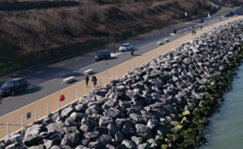
Key outcomes: The project provides an increased level of protection from coastal erosion and flooding to 200 homes and businesses, as well as critical infrastructure such as the A55 North Wales Expressway and the North Wales Coast Railway Line.
A shared-space cycleway with related facilities, health markers and improved access to the beach has promoted numerous fitness related activities returning to the frontage.
The project achieved CEEQUAL rating of ‘Excellent’, and was subsequently shortlisted for the CEEQUAL Outstanding Achievement Award for its extremely ambitious and comprehensive approach to sustainability.
The scheme has been designed and constructed with inclusivity in mind with gently sloping access ramps onto the raised promenade and fishing platform areas, and disabled parking provision.
Through the involvement of the community in the development of a common vision for the improved promenade, a space has been created that provides a sense of belonging to all members of the community.
Stephenson Street flood alleviation scheme
Organisation: Natural Resources Wales
Project location: Stephenson Street, Liswerry, Newport
Main funding stream: Welsh Government FCERM Programme
Source: Sea flooding
Project description: Stephenson Street is NRW’s largest and most complex flood scheme ever. Approximately 2km of raised defences (flood bund, sheet pile and reinforced concrete walls) have been constructed within budget and programme in a complex urban location, next to nationally significant sensitive saltmarsh, businesses and utilities. NRW adopted a one-team collaborative approach, innovation and design from first principles which enabled delivery of low-carbon, sustainable solutions as well as the early identification and utilisation of a local supply chain. In order to overcome significant constraints, the scheme has been constructed in an efficient and environmentally sensitive manner that safeguards the Wellbeing of Future Generations.
Figure 4: Photo showing the construction of the Stephenson Street flood alleviation scheme

Key outcomes:
- 194 homes and 620 businesses better protected from tidal flooding across Liswerry.
- When climate change is taken into account, 1,100 homes and 1,000 non-residential properties are better protected from tidal flooding across Liswerry.
- Enhancements to community green spaces and the nearby section of the iconic Wales Coast Path.
- Exceptional value for money with every £1 spent delivering £8 over its life.
Major flooding incidents
During the reporting period for this report April 2023 to March 2025, there have been a number of storms which have led to impacts across Wales. If there is property flooding in a certain area, the LLFA that manages that particular source of flooding may be required to produce a section 19 report on the flooding. The table below contains any Section 19 reports that have been published during this reporting period or for flooding that occurred during the reporting period and submitted to us. We are unclear if this is a complete record of all Section 19 reports during the reporting period which highlights some of the challenges with the National oversight of this process.
Table 10: Section 19 reports produced by Local Authorities
|
Local Authority |
Location |
Date of flood event |
Date published |
Link to Section 19 report |
|---|---|---|---|---|
|
Conwy County Borough Council |
Llandudno |
October 2023 (Storm Babet) |
- |
Report available on request from Conwy County Borough Council
|
|
Conwy County Borough Council |
Llanfairfechan |
April 2024 (Storm Pierrick) |
- |
Report available on request from Conwy County Borough Council |
|
Conwy County Borough Council |
Kinmel Bay |
April 2024 (Storm Pierrick) |
- |
Report available on request from Conwy County Borough Council |
|
Neath Port Talbot Council |
Melyn |
3 November 2022 |
17 January 2024 |
|
|
Swansea Council |
Lower Gorseinon |
February 2020 (Storm Dennis) |
13 October 2025 |
|
|
Wrexham County Borough Council |
Worthenbury |
16 October 2024 |
18 July 2025 |
Section 19 flood investigation reports | Wrexham County Borough Council |
Storms and impacts affecting Wales between April 2023 and March 2025
The chart below shows the flood risk forecast for Wales every day for the past two financial years. There is one coloured line for each day to indicate the forecast flood risk. Red indicates high risk of flooding, orange is medium, yellow is low and green is very low.
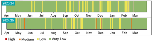
Figure 5: Figure showing the flood risk forecast for Wales for each financial year for the past five years. For each year, there is a line for every day of the year, shaded according to the predicted flood risk.
The following sections summarise the major storms and their associated impacts that have affected Wales from April 2023 to March 2025.
Unnamed storm, 20 September 2023
The remnants of Hurricane Lee which caused impacts in Bermuda, the US and Canada caused high winds and bands of heavy rain that caused flooding of roads and disruption in Swansea, Carmarthenshire and Powys. At Clydach in the Tawe valley, the river Clydach peaked at 4.16m and led to flooding of the Mond Valley Golf club and the Vardre Rugby Football Club pitches and buildings.
Storm Babet, 18 to 21 October 2023
Storm Babet was the third wettest independent 3-day period across the whole of England and Wales since 1891. Impacts were felt in communities across North and Mid Wales as the storm triggered 46 flood warnings of varying levels in a 48-hour period demonstrating the huge amount of rainfall that fell in this area of Wales over a relatively small period of time. Transport was affected as roads and railways were flooded and many schools were forced to close. In some areas properties were evacuated as a result of the heavy rain and rising floods which led to the flooding of approximately 160 properties in Conwy, Denbighshire, Flintshire, Wrexham and Powys. A severe flood warning meaning that there is a danger to life was issued for Llandrinio, Powys covering the area where the Severn and Vyrnwy rivers meet.
Storm Ciaran, 31 October to 1 November 2023
Storm Ciaran caused very strong winds and heavy rain soon after Storm Babet. The already saturated catchment of the River Ritec in Tenby meant a Severe Flood Warning was issued as the river reached record levels. NRW attended the multi-agency response and the advice given led to the safe and successful evacuation of over 900 people to safety as flood waters inundated the Kiln Park Holiday site in the area.
Storm Henk, 2 January 2024
Storm Henk was the 8th named storm of the season and led to widespread disruption with strong winds and heavy rain across Wales. Worst affected was the River Ritec in Tenby that was subject to a severe flood warning and flooding of the Kiln Park caravan park for the second time this winter.
Storm Isha, 21 to 22 January 2024
Storm Isha brought winds as strong as 90mph accompanied by some very wet weather that saw the high ground of North Wales receive 50mm of rainfall widely and in places, over 100mm. Roads were flooded in North Wales along with much disruption caused by the strong winds. The flood risk posed by Storm Isha was diminished due to arriving after a fortnight of cold and dry weather.
Storm Kathleen, 6 – 7 April 2024
Storm Kathleen was an unusually severe storm for this time of year with very strong winds, especially in coastal areas which also coincided with a period of springs tides, and heavy rain. The stormy conditions particularly affected the Western and Northern parts of Wales. In total, 35 properties experienced internal flooding across Conwy, Ceredigion and Torfaen.
Storm Lilian, 22 – 23 August 2024
Storm Lilian was the 12th and final storm of 2023/24 storm season and the first time named storms reached the letter L in any storm season. Storm Liliam was the most significant August windstorm to affect the UK since storms Ellen and Francis in August 2020. Strong winds affected coastal areas around Wales leading to Flood Warning and Flood Alerts to be issued.
Unnamed storm, 16 October 2024
Widespread disruption was experienced in many parts of Wales, particularly in Powys and the North East as heavy rain fell causing flooding to properties, trainlines and roads.
Storm Ashley, 20 – 21 October 2024
Storm Ashley was the first storm of the 2024/25 storm season causing heavy rain and very strong winds across Wales but mostly impacting coastal areas and communities. Sea flooding was experienced around the coast including in coastal communities Borth, Amroth and Aberystwyth along with surface water flooding in Cardiff.
Storm Bert, 22 – 25 November 2024
Over the weekend of the 23 to 24 November 2024, storm Bert brought a period of very wet and windy weather to Wales. There were widespread rainfall totals of 50 to 100mm across Wales with over 150mm of rain in the wettest upland areas. In many places in South Wales, the rainfall amount in the three day period from 22 to 24 November was 70% or above of the November average rainfall. The 23 November was the wettest day in the UK since October 2020 and the 12th wettest in the UK series from 1891. This amount of rainfall falling on already wet catchments led to some rivers in South Wales reaching their highest ever recorded levels.
Steep sided catchments like the south Wales Valleys, respond very rapidly to heavy downpours. Storm Bert brought very heavy rainfall that was very challenging to forecast exactly where it was going to impact. The Taff catchment rivers responded incredibly quickly to the rainfall, giving short lead time for warnings to be issued. During Storm Bert more than 700 homes across Wales experienced flooding, with Pontypridd which was badly affected during storm Dennis in February 2020, one of the most severely affected communities. A landslip occurred at Cwmtillery, Blaenau Gwent, with a disused coal tip partially collapsing, forcing the evacuation of around 40 homes due to rock and mud flowing onto residential streets. In addition, a large sinkhole opened on a residential street in Merthyr Tydfil after an underground culvert was damaged by boulders.
As a result of Storm Bert, flooding and infrastructure damage led to widespread disruption of railways, including the closure of the Heart of Wales and Marches lines. Many roads were also closed due to flooding and landslides, including the A479 in Powys and the A4042 in Monmouthshire.
Storm Darragh, 6 – 7 December 2024
Storm Darragh caused very strong winds to West Wales and coastal areas along the South Wales coastline resulting in a rare red warning being issued by the Met Office. The UK Government also issued an emergency alert by phone to those affected areas. This was the first time this system had been used since being introduced in 2023.
Storm Darragh arrived just two weeks after storm Bert so the risk of flooding was also a concern as storm Darragh led to 50 to 100 mm of rain to upland areas of Wales on already saturated catchments. There was widespread travel disruption, damage to buildings and infrastructure. The destructive winds significantly damaged power infrastructure with more than 259,000 homes without power at the peak of electricity network disruption. Although 110 flood alerts and 41 flood warnings were issued throughout the duration of storm Darragh, flooding impacts were minimal.
Examples of good FCERM practice in Wales
The following section presents a range of projects and case studies delivered in this reporting period, recognised as good practice for innovation, the use of natural flood management techniques, partnership working, information provision or community participation.
Figure 6: A map providing an overview of the examples provided.

Novel or innovative projects
Public-facing data platform - Wales Coastal Monitoring Centre (WCMC) and Office for National Statistics (ONS)
Organisation: Wales Coastal Monitoring Centre (WCMC)
Project location: Wales coastline
Key partners: Office for National Statistics
Source: Sea flooding and coastal erosion
Project description: The WCMC has delivered a pioneering collaboration with the Office for National Statistics Data Science Campus to develop a public-facing data platform. This tool provides open, immediate access to coastal change evidence, supporting improved transparency and enabling Risk Management Authorities and other stakeholders to make informed, data-driven decisions. The platform represents a major step forward in the use of digital innovation to support FCERM across Wales.
Figure 7: Screenshot from the Wales Coastal Monitoring Centre data platform showing beach profiles for Newgale Sands North
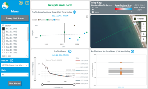
Key outcomes: Open access to coastal change evidence
Risk Based Revenue Allocation Model (RBRAM)
Organisation: Natural Resources Wales
Project location: Wales
Main funding stream: Welsh Government FCERM Programme
Source: Main river and the sea
Project description: We have developed a new method of planning our routine maintenance activities, utilising our asset management database (AMX), which will enable us to prioritise routine asset maintenance and allocate funding in a more efficient and effective way. The RBRAM Model works by considering factors including the level of risk, the criticality of undertaking certain actions, the economics of each action and whether there are other drivers for our work, including legal commitments. We have developed the model over recent years and we are continuing to improve the guidance, standards and specifications in relation to this work. As we capture more data from the delivery of our maintenance work we are continuously improving the evidence and assumptions made by the model.
Key outcomes: RBRAM will enable us to ensure our flood risk asset maintenance is prioritised on a risk basis, ensuring we deliver the best value for money through our works whilst also ensuring that maintenance obligations are met.
Rhymney Great Wharf Polders
Organisation: Natural Resources Wales
Project location: Rhymney Great Wharf, Cardiff
Main funding stream: Welsh Government Nature Network Programme
Source: The sea
Project description: Work to restore the saltmarsh habitat along the Severn Estuary near the Rhymney Great Wharf in south Wales, has been completed. The project will help to increase biodiversity and resilience in the Estuary as well as reducing flood risk in the area.
The restoration has included the renewal and extension of over 2km of sedimentation polders along the foreshore. The structures, which are made of chestnut posts and brushwood bundles, help encourage the establishment of saltmarsh habitat, by slowing the movement of the tide as it recedes, allowing sediment to be deposited within the polder fields.
Over time, mud and sand builds up and turns into saltmarsh.
Figure 8: Rumney Great Wharf Polders
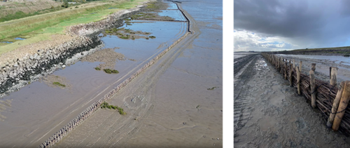
Key outcomes: This will help restore the important habitat of the Severn Estuary, supporting local wildlife and helping to trap carbon. The Estuary supports some of the most important and protected habitats in the UK, and is designated as a Special Area of Conservation (SAC). It hosts a significant number of waterfowl and aquatic invertebrate as well as providing a valuable corridor for migratory fish.
This nature based solution will also help to enhance the existing flood defences and reduce future flood risk by reducing pressure from erosion.
The use of Natural Flood Management (NFM)
Afon Bidno, Upper Wye catchment NFM project
Organisation: Natural Resources Wales
Project location: Afon Bidno, Upper Wye catchment
Main funding stream: Welsh Government’s Nature and Climate Emergency Fund
Source: Main river
Project description: We have undertaken work on the Afon Bidno in the Upper Wye catchment to help slow the flow and provide habitat benefits for wildlife. Along a 1.5 km stretch of the Afon Bidno in our Welsh Government Woodland Estate, we have placed large deadwood in the watercourse to help slow the water flow and provide a greater variety of river features and habitats for wildlife. We have also partially cut bankside willow trees to encourage the growth of thicker trees which will provide shade for the river, create habitat and slow overland flow. These living willow trees will help to slow the flow indefinitely, even when the woody debris has decayed. These techniques provide food for aquatic insects, and in turn amphibians, fish and otter, some of which are designated species in this Special Area of Conservation (SAC). The slower flows and bankside vegetation, particularly in high flow events, will also cause suspended sediments to drop out of the water and be retained on site, thus reducing colouration of the watercourse from soils washed off the land.
Figure 9: Photo showing a leaky dam across the Afon Bidno

Key outcomes: This project presented a low cost and effective means of delivering a range of environmental and land management benefits, including flood risk.
As a result of the success of these techniques on the Afon Bidno, we plan to adopt these same techniques to deliver benefits for water quality and river health on other sites across the Wye catchment and beyond.
River Trothy NFM
Organisation:
Monmouthshire County Council
Project location: River Trothy Catchment
Key partners: Landowners
Main funding stream: Welsh Government Natural Flood Management (NFM) Grant
Project description: With funding received from the Welsh Government Natural Flood Management (NFM) grant, Monmouthshire County Council worked with local landowners to develop NFM schemes in the River Trothy catchment which feeds the River Wye south of Monmouth. The scheme included improvements at two sites where the landowners were fully engaged in the process of designing and implementing NFM features to help reduce flood risk and provide biodiversity improvements.
At both sites, the landowners helped to develop the NFM proposals. At one site, one dew pond, four scrapes, five leaky dams and 14 ponds were created, totalling approximately 3,300 cubic metres of storage. At the second site, the works included leaky debris dams, gully stuffing, attenuation ponds, scrapes, and a small lagoon to intercept overland runoff. The features were installed in the upper catchments of a number of small streams and ditches using natural materials sourced immediately adjacent to the works. Following completion, a NFM training and awareness event, organised by the Wye Valley National Landscape for contractors, landowners and other interested parties, was held on the farm which included a talk on NFM and site visit to see the completed NFM features and some new leaky dams being installed. The works were completed by local contactors supported by the landowners.
Figure 10: Photo showing a pond that was created as part of the NFM improvements in the Trothy catchment
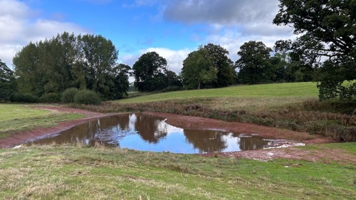
Key outcomes: Successful delivery of two NFM schemes which will help to reduce flood risk and provide biodiversity enhancements and also have the potential for future expansion of NFM features.
Lessons learnt: Engagement with landowners is key. This can be time consuming, but with shared goals, landowners and Monmouthshire County Council’s engineers have worked closely to ensure the projects were a success.
Dolwyddelan NFM
Organisation: Conwy County Borough Council
Project location: Dolwyddelan
Main funding stream: Welsh Government Natural Flood Management (NFM) Grant
Project description: This project sought to address surface water and small watercourse flood risk identified by NRW flood mapping and which was impacting on residential property. The land belongs to private landowners who had made contact with Conwy County Borough Council (CCBC) about a flood issue arising from a small stream and overland flow in fields above their property, which sits above the village of Dolwyddelan.
Initial surveys and site investigations identified various interventions which would not compromise the land for grazing now and in the future. These interventions include reducing the flood flow within the watercourse with leaky woody debris, identifying historical bog areas and creating pathways using bunds and brash bundles to retain water and nutrients within the soil that were previously lost during periods of significant rainfall and overland flows.
During construction, CCBC worked with the adjacent landowners to ensure no negative effects were caused further down the valley from where the works took place.
Figure 11: Photo showing woody debris dam used to help slow the flow of water

Key outcomes: Reduced surface water flood risk and increased biodiversity benefits.
Lessons learnt: Early engagement with the consultant / contractor helped to maximise the potential for NFM opportunities and early engagement with landowners helped to understand present and historical use to ensure the scheme has no detriment to the ongoing use of land.
NFM in Schools Project
Organisation: Caerphilly County Borough Council (CCBC)
Project location: Multiple schools across Caerphilly County Borough, Wales
Key partners: Welsh Government, Countryside and Parks Services, Ynysddu Primary School, Cwmfelinfach High Level Primary School, Waunfawr Primary School, Crumlin High Level primary School, Ystrad Mynach Primary School, The Twyn School
Main funding stream: Welsh Government’s Natural Flood Management Accelerator Programme
Project description: The NFM in Schools Project delivered sustainable drainage systems (SuDS), including ground-level features (rain gardens), rainwater butts and SuDS planters, across several schools in Caerphilly County Borough. These interventions aimed to manage surface water, enhance biodiversity, and educate pupils on environmental sustainability. The scheme included educational signage and planting activities coordinated with school timetables. A notable milestone was the visit by the Minister for Climate Change at the time, Julie James MS, to one of the participating schools, which highlighted the project's success and its alignment with national climate resilience goals.
Figure 12: NFM in schools. (Left to right) Photo 1 is a rain garden in Ystrad Mynach, photo 2 is raised rain garden in Ystrad Mynach and photo 3 is a rain garden in Crumlin High
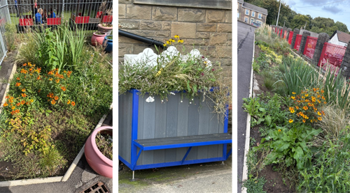
Key outcomes:
- Flood resilience improved at educational sites
- Pupils engaged in environmental learning
- SuDS signage installed for long-term awareness
- Project completed under budget due to efficient collaboration
Lessons learnt:
- Coordinating works around school schedules was challenging but manageable through close collaboration.
- Listed building requirements (e.g., downpipe configurations) required adaptive planning.
- Educational signage reinforced the scheme’s long-term value.
- The project serves as a replicable model for integrating sustainable drainage in school environments.
Partnership working
Partnership Working and Community Participation
Organisation: Pembrokeshire County Council (PCC)
Project location: Havens Head and Lower Priory, Milford Haven
Key partners: Milford Haven Port Authority
Main funding stream: Welsh Government FCERM Programme
Source: Surface water
Project description: Pembrokeshire County Council (PCC) are undertaking a flood alleviation scheme to address flooding issues for communities in the Milford Haven area following flooding in 2018. The scheme will involve culvert and outfall upgrades along with NFM work and watercourse bank repairs. PCC have undertaken multiple engagement events with the communities at risk of flooding, and also with the main land owner, Milford Haven Port Authority to ensure the final scheme is appropriate. The engagement events have been held face to face in the community and involved talking through the latest proposals, answering questions and addressing any concerns the local community might have. There have also been multiple site visits for residents and elected Members.
Key outcomes: Flood risk alleviated for properties, businesses and wider infrastructure (including highways).
Lessons learnt: Flooding happened in 2018 which impacted two communities in the area. Community members and affected residents still have a huge drive and desire for the work to be completed so it is important that these are included in the development of the project.
Partnership Working: The Joint FCERM R&D Programme
Organisation: Natural Resources Wales (NRW), in partnership with the Joint Flood and Coastal Erosion Risk Management (FCERM) Research & Development (R&D) Programme
Project location: The programme operates at a Wales and England level
Key partners: Department of Environment, Food & Rural Affairs (Defra); Environment Agency (EA); Welsh Government (WG)
Main funding stream: NRW Revenue with contributions from others key partners (listed above)
Project description: The Joint FCERM R&D Programme is a partnership between Defra, the Environment Agency (EA), Welsh Government (WG) and NRW. Together, this programme identifies and delivers flood-risk research across England and Wales. We have agreed a set of “Areas of Research Interest” (the current period runs to 2028) to focus our work. All reports, such as the updated “Working with Natural Processes Evidence Directory” (Feb 2025) are available on GOV.UK. When publishing projects there are webinars and workshops so Local Authorities, engineers and community groups can put the findings to work.
A good example of the benefits of partnership working at both a programme and project level is the “Working with Natural Processes to Reduce Flood Risk” (2025) project. Working with Natural Processes aims to protect, restore and emulate the natural functions of catchments, floodplains, rivers and the coast to reduce flood risk. It is often referred to as natural flood management or nature based solutions (NbS). This project has reviewed the latest evidence to provide a comprehensive report on the effectiveness of 17 individual measures in reducing flood risk and the multiple benefits they provide. Through working in partnership, the project recognised the different policies around NFM / NbS in Wales and the need for good evidence to support implementation of these policies. Subject matter experts from NRW supported the project, reviewing outputs and helping to shape the final products. Being involved in these discussions allowed greater understanding of the evidence to support future approaches to NbS in Wales.
Key outcomes:
- Shared Priorities: By establishing shared research priorities across England and Wales via the Areas of Interest, the Programme ensures that new studies align with operational policy needs, addressing critical knowledge gaps and directly informing frontline FCERM decision-making.
- Shared Expertise & Data: By collective working together sharing knowledge, skills and data. Key topic areas such as NFM are progressed avoiding duplication of effort and maximising areas of opportunity.
Lessons learnt: The power of Influence: Joint promotion by all partners boosted sector-wide engagement far beyond what any single body could achieve.
Maesycwmmer culvert
Organisation: Caerphilly County Borough Council (CCBC)
Project location: Pontprencrwca House, Maesycwmmer
Key partners: Welsh Government, Private Landowners
Main funding stream: Welsh Government FCERM Small Scale Grant, Storm Bert Emergency Funding and CCBC Core Capital Budgets
Project description: In the aftermath of Storm Bert, a historic masonry arch culvert running under the Nant Y Twyn road was inspected and found to be 50% collapsed. The road was closed whilst engineers came up with a solution to replace the collapsed section. There were significant challenges including a Welsh Water main pipe, closing rural country lane, working through extreme weather conditions, asbestos deposits in the ground and navigating bedrock.
A new box culvert was installed and boundary wall replaced with works completed to a high standard and the road re-opened.
Figure 13: Photo on the left shows the damaged culvert following Storm Bert and the photo on the right shows the culvert after repairs.
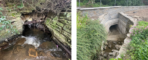
Key outcomes: Flood relief for the highway, residential homes and surrounding areas.
Lessons learnt:
- Co-ordinating with stakeholders is imperative to drive a successful project management scheme.
- Residential engagement and regular contact is important.
- Significant financial and time impacts can occur with even the most minor of design adjustments.
- Stakeholder meetings should be held throughout the project to ensure all parties are on the same page.
Information provision
New Flood Warning Information Services for Wales
Organisation: Natural Resources Wales
Project location: Wales
Main funding stream: Welsh Government FCERM Programme
Source: Main river and the sea
Project description: NRW’s new Flood Warning Information Services for Wales (FWISfW) went live on 17 July 2024. Issuing flood warnings are critical for us to fulfil our statutory obligation to warn others of the location, timing, and magnitude of flooding from rivers and the sea in Wales. It has since been used to successfully issue Flood Alerts and Flood Warnings for river and coastal flooding, including during Storm Bert and the other winter storms of 2024/25.
This was a significant £5m project which has enabled us to deliver a new multi-media Flood Warning Information Services for Wales. This project now allows us to provide our own independent flood warning service for the people of Wales. For continued consistency for our customers, the flood warning codes, thresholds we issue warnings at and properties we send warnings to did not change on go live.
Key outcomes: The new Flood Warning Information Services for Wales allows for a more efficient process for issuing Flood Alert and Warning messages by our duty officers, so it is reduces their workload during flooding incidents and enables faster issuing of messages to those at risk. It also enables better clarity and consistency in our Flood Alert and Warning messages so that they provide more direct advice, related to potential or expected impacts.
Lessons learnt:
- Putting users at the heart of the service design is essential to make better investment decisions and develop better processes.
- Direct engagement and research with users is important to determine who the customer is when considering changes to a service.
- The discovery and pilot phases are worth the time and effort especially when considering whether to deliver an off the shelf IT solution or build a bespoke solution.
- With ICT projects, strict control of the delivery timetable is needed to deliver to time and budget. This was done successfully and go live took place as planned in July 2024.
Telemetry replacement project
Organisation: Natural Resources Wales
Project location: Wales
Main funding stream: Welsh Government FCERM Programme
Source: Main river and rainfall
Project description: NRW are undertaking work to deliver a new Telemetry System with an estimated project cost of £5m. This project is critical to enable NRW to continue to gather and share near real time river, rainfall and operational plant information which underpins our response to flooding incidents and water management, including drought. It will replace ageing systems and infrastructure which are reaching the end of operation. The new telemetry data portal is live and all external customers have migrated over to it. 565 out of 611 telemetry stations have been transferred to the new system. Work on the main system build continues into 2025/26.
Key outcomes: The new system will provide near real time river, rainfall and operational plant information which is critical to our response to flooding incidents.
Shoreline Management Plan (SMP) Layer update on coastal risk map
Organisation: Natural Resources Wales
Project location: Wales
Main funding stream: Welsh Government FCERM Programme
Source: Sea flooding and coastal erosion
Project description: As part of NRW’s ongoing SMP refresh work, improvements were made to how Shoreline Management Plans are presented on the online maps (accessible via our webpage) with greater detail added to the information and content, with improved links to source material.
Figure 14: Screenshot from our webpage showing how we present our Shoreline Management Plans

Key outcomes: The additional Policy Rationale, Policy Sub-Categories and links to source Policy documents provide more detail on the proposed policies to clarify the local intent and management approach going forward.
Long Term Investment Requirements (LTIR)
Organisation: Natural Resources Wales
Project location: Wales
Main funding stream: NRW Revenue funding
Source: Main river and the sea
Project description: In January 2024, NRW published a report looking at the level of investment required in flood defences to manage Wales’ future flood risk from rivers and the sea against the backdrop of a changing climate.The Long Term Investment Requirements (LTIR) report sets out the findings of the LTIR analysis, using the latest information from the Flood Risk Assessment Wales (FRAW) project and the Asset Management eXpert (AMX) flood asset database. An economic tool was used to assess different investment scenarios, the likely costs and benefits of different policy decisions to help inform decision making and budget planning for Flood Risk Management (FRM) in Wales.
Key outcomes: The report highlights the need for further action in response to our changing climate, the need for adaptation across many communities around Wales and the sustained need for investment in flood risk management over the long term.
Flood Risk Management Plans (FRMPs)
Organisation: Natural Resources Wales
Project location: Wales
Main funding stream: NRW Revenue funding
Source: Main river and the sea
Project description: NRW published updated Flood Risk Management Plan in November 2023. The plan covers all of Wales and sets out the priorities for managing flood risk for the next six years for the areas of flooding for which we have lead responsibilities: flooding from rivers, reservoirs and the sea. The plan is separated into an overarching national section alongside six place focussed sections.
Key outcomes: The set of planned measures and actions included in the plan will address the overall objective of reducing the risk to people and communities from flooding from main rivers, reservoirs and the sea, and support the delivery of the 14 priorities set out within the plan.
Community participation
Flood volunteer network events
Organisation: Natural Resources Wales
Project location: Cardiff, Aberystwyth, Merthyr Tydfil and Llandudno
Key partners: Professional partners including Local Authorities, Flood Re, Association of British Insurers, Public Health Wales, REACT Disaster Response and National Flood Forum.
Main funding stream: NRW Revenue funding
Source: All sources
Project description: NRW held 3 Community Flood Volunteer network events in Cardiff, Aberystwyth and Llandudno during 2023/24 and 2 in Aberystwyth and Merthyr Tydfil in 2024/25. These events provided a valuable opportunity to connect with public and partners face to face.
In the 2023/24 events, NRW developed a fictional flood scenario, which unfolded over the course of a few days, and seated people from different communities and organisations together to work through the scenario. In total, 23 communities were represented by 39 community members along with 65 professional partners.
The 2024/25 events focused on flood recovery. There were short presentations from professional partners and NRW explaining their roles and support offered in the flood recovery process. In total, 12 communities were represented by 24 community members. 43 professional partners attended and contributed to the planning and discussions on the day.
Figure 15: Community Flood Volunteer network event at the Angel Hotel, Cardiff, 28 September 2023
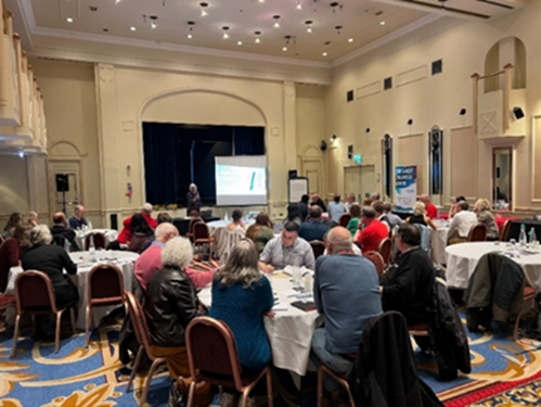
Key outcomes: These events provide a valuable opportunity for face-to-face interaction between organisations and the opportunity to talk to others about flood risk.
Sustainable Coastal Communities
Organisation: Pembrokeshire County Council (PCC)
Project location: Saundersfoot, Amroth and Dale
Key partners: Saundersfoot Community Council, Pembrokeshire Coastal Forum, Saundersfoot Harbour, Amroth Community Council, Dale Community Council
Main funding stream: Revenue
Source: Coastal erosion
Project description: Sustainable Coastal Communities is an initiative that started with involvement with affected communities, particularly considering how communities around the coast may need to adapt with climate change. Using the Shoreline Management Plan 2 (SMP2) and accompanying action plans, consultant support helped create community specific information sheets detailing information on sea level rise, SMP2s, flood risk (including flood modelling), coastal change, current and possible future management practises and planning policy.
Key outcomes: Producing the community specific information sheets has enabled the start of community led discussion for climate adaptation in coastal communities. Each location (Amroth, Dale and Saundersfoot) have different SMP2 policies and action plans, therefore each discussion is different. The community will lead on the decision making, with Pembrokeshire County Council assisting. Discussions with communities are ongoing with no set end date.
Lessons learnt: There is not one rule that fits all communities with regards to conversations with communities regarding change and adaptation.
Ynysddu Flood Group
Organisation: Caerphilly County Borough Council
Project location: Ynysddu, Caerphilly
Key partners: Local Ward Councillors, residents, NRW
Main funding stream: FCERM element of Revenue Support Grant
Project description: The Ynysddu Flood Group is a community-focused initiative aimed at addressing surface water flooding concerns across Bridge Street, Station Avenue, and John Street in Caerphilly. The group operates throughout the year, maintaining regular liaison with local councillors who act as a conduit for ongoing concerns raised by residents. Engagement intensifies in the lead-up to the group’s annual meeting, typically scheduled for early autumn. Prior to this meeting, a preliminary site walkover is conducted with councillors to identify and highlight key areas of concern. This is followed by a formal meeting involving residents, councillors, and representatives from Natural Resources Wales (NRW), who attend in their capacity as the Risk Management Authority for main river flooding. The meeting provides a platform to discuss persistent issues in greater detail and is followed by a joint walkover involving all stakeholders to ensure that all flood-related concerns are observed and understood on the ground. Following these activities, a summary is produced, and any necessary actions are pursued and monitored throughout the year.
Figure 16: Photo showing Ynysddu Flood Storage Area
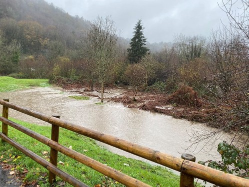
Key outcomes: This structured and collaborative approach ensures that local flood risk is managed proactively and transparently, with strong community involvement and inter-agency coordination.
Natural Resources Wales Annual Reports
To provide more detail and regular reporting, in regard to the progress being made in managing flood risk in Wales, Natural Resources Wales have produced a series of annual reports over the last three years to supplement the information supplied in this overarching Section 18 Report.
The information included helps to demonstrate the wider delivery of Welsh Governments National Strategy and its Objectives, they also provide more in depth detail into some of the key projects and successes delivered within this reporting period.
These reports cover the financial year period from April to March and can be accessed using the following links.
Flood risk management annual report 2020/21
Flood risk management annual report 2021/22
Flood risk management annual report 2022/23
Other places in Flooding reports, evidence and data
Last updated